2

Cascade County, number 2 on Montana license plates, was formed by a legislative act on September 12, 1887, two years before Montana Territory was admitted as a state. The county was formed from land taken from Chouteau, Lewis and Clark, and Meagher Counties. Both the county and its seat, Great Falls, are named for the series of waterfalls on the Missouri River that blocked Lewis and Clark on their upriver travel in 1805, forcing them to portage around "the thundering great falls." Bonds were sold for construction of the county's court house in 1901, and over the next two years, the building still serving was built--coming in over budget, of course. Originally the dome was to be of stone, but in the end, copper was used instead. The rest of the building is made of locally quarried sandstone.
 Cascade County Court House (1901-1903)
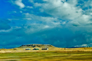
Long Montana's number 2 city, by 2000 Great Falls had fallen to third place after Billings and Missoula, and Cascade County to fifth. The county lies east of the Continental Divide, and slopes down from the Rocky Mountain front into the rolling plains of north central Montana. The western edge of the county is still quite mountainous, with many isolated outcroppings such as the mesa shown here just north of the town of Simms, Montana.
 Mesa, western Cascade County
 Great Falls was the home of artist Charlie Russell, and his studio has been preserved on the grounds of the C.M. Russell Museum. So important is Charlie Russell to Montana history, that most Montana cities have a CM Russell school and one of the required items on Montana license plates is Russell's signature buffalo skull, which is used on current standard plates to separate the county number from the vehicle number. Russell is also one of two artists enshrined in the U.S. Capitol's statuary hall. The Museum holds an art show and sale every year--an event that has become so popular that Great Falls now hosts three separate art auctions annually.
The Missouri River flows north across Cascade County, and the city of Great Falls has preserved much of the river front as park land. The view below shows the new (2010) Federal Court House that has been built on the banks of the Missouri.
The Missouri River flows north across Cascade County, and the city of Great Falls has preserved much of the river front as park land. The view below shows the new (2010) Federal Court House that has been built on the banks of the Missouri.
 View across the Missouri River, toward the new (2010) Federal Court House
Historically Great Falls has served as a major transportation center, shipping grain out of central Montana on the Great Northern, the Northern Pacific, and now the Burlington Northern Santa Fe Railroad. It was the home of one of the Anaconda Company's smelters, and when ARCO, who had bought operations from the Anaconda Company ceased production statewide, five percent of Cascade County's population lost work. Great Falls is also home to Malmstrom Air Force Base, and the possibility of closing the base due to reductions in the US Armed Forces is a constant worry for local business and government alike.
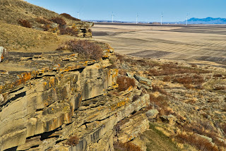
 View to the East from the Ulm Pishkun (Buffalo Jump)
The view above was taken at the Ulm Pishkun, now known as First People's Buffalo Jump, a state park located west of the city of Great Falls. In the photo above, we're looking east toward the city, a small windfarm located near the International Airport, and in the distance, the Highwood Mountains. Pishkuns, or Buffalo Jumps, are located all over Montana. They are places where a naturally occurring cliff allowed native people to lure buffalo to their death by stampeding them over the cliff. This allowed people who had no horses prior to the Spanish conquest of North America to gain food, clothing and shelter from the animal central to their very existence. Today the park has an interpretive center and good signage allowing us all to learn about this important aspect of native life.
The 2000 US Census showed 80,357 people living in Cascade County. This number, which had been relatively static since 1970, increased 2.1% by 2008 to an estimated population of 82,026. With a land area of 2,698 square miles, the 2000 census meant a population density of 29.8 people per square mile--most of them living within the city limits of Great Falls. Racially Cascade County is a good mirror of the state as a whole, with 90.6% of the population being white. There is a higher percentage of African Americans in Cascade County than state-wide, largely because of the airbase, and a lower percentage of Native Americans.
You can read more of my writing about Great Falls on my June 16, 2009 blog.
Photo Information:
Note that all photos will open in a larger format and in a new window if you double click on them.
Cascade County Sign: Taken 3/26/2010 at the Judith Basin/Cascade County line on Montana Highway 200. Nikon D80 DSLR, Nikkor 16-85 mm wide angle/tele/zoom lens set at 72 mm. ISO 125, f /16.0, 1/10 second. Finished in Photoshop CS4.
Cascade County Court House: Taken 3/14/2010 in Great Falls, Montana. Nikon D80 DSLR, Nikkor 16-85 mm wide angle/tele/zoom lens set at 22 mm. ISO 125, f /11.0, 1/90 second. Finished in Photoshop CS4.
Mesa: Taken 3/26/2010 near Simms, Montana. Nikon D80 DSLR, Nikkor 16-85 mm wide angle/tele/zoom lens set at 16 mm. ISO 125, f /16.0, 1/20 second. Finished in Photoshop CS4.
Missouri River and Federal Courthouse: Taken 6/13/2009 in Great Falls, Montana. Nikon D80 DSLR, Sigma 18-50 mm wide angle/tele/zoom lens set at 50 mm. ISO 125, f /5.6, 1/750 second. Finished in Photoshop CS4.
View from Ulm Pishkun: Taken 3/14/2010 near Ulm, Montana. Nikon D80 DSLR, Nikkor 16-85 mm wide angle/tele/zoom lens set at 85 mm. ISO 125, f /11.0, 1/125 second. Finished in Photoshop CS4.


No comments:
Post a Comment