Thursday, April 22, 2010

7. Flathead County, Montana


7


As I have noted in earlier posts, at the time Montana Territory was created in 1864, most of the land west of the Continental Divide was in Missoula County, first formed in 1860 as one of the counties of Washington Territory. Montana became a state as part of the Omnibus Statehood Act of 1889, and Missoula County remained undivided. That would change in the 1890s. In 1891, the Great Northern Railroad arrived in the Flathead Valley and established its division point north of Flathead Lake. In 1892, the city of Kalispell was incorporated around that railroad division point, and in 1893, Flathead County was created out of the northern extent of Missoula County. In years to come, Lincoln (number 56) and Lake (number 15) Counties would be formed out of Flathead.


The Flathead County Court House

Flathead County was established in 1893 and the courthouse built in 1903. The county takes its name from Flathead Lake, the largest freshwater lake in the U.S. west of the Mississippi River, which in turn is named for the Salish people native to the area erroneously named the Flathead Indians by early explorers. The county seat is Kalispell.

Flathead Lake and the Mission Mountains

Today, Flathead County is one of Montana’s fastest growing areas. It offers year round recreational opportunities situated as it is between Glacier National Park and Flathead Lake. One of Montana's main destination ski resorts is The Big Mountain, located just north of Whitefish, Flathead County's second largest city. Whitefish is served by Amtrak, as is Essex, at the southern end of Glacier National Park. The Izaac Walton Inn at Essex was originally the Great Northern Station and Hotel. Essex is the point where the railroad puts extra locomotive power on trains to get them over the Continental Divide at Marias Pass, just a few miles east. I always try to schedule my trips through the area so that I can have either lunch or dinner at the Inn. For the really adventurous, the Inn has railcars refurbished as overnight cabins, and they're working on redoing a locomotive to serve as a cabin.

Lake MacDonald, Glacier National Park

In 2000, the US Census showed 74,471 people living in the community. The 2009 estimates indicate a 20.3% growth rate, with an estimated county population of 89,624, making it the fourth most populous county in Montana. Flathead County is unusual in Montana in that there are five communities in the county with a population over 1500. Each city has its own feel and atmosphere. Most have resort-based economies. Some of the best theatre I've ever enjoyed was at the Bigfork Summer Playhouse, at the northeast corner of Flathead Lake.

While no interstate highway comes close to Flathead County, you can drive there on US 93 which stretches from Phoenix Arizona to the Canadian border and, as British Columbia 93 continues on toward Revelstoke, Radium Hot Springs and Kootenai National Park, then as Alberta 93 through Banff National Park and Jasper National Park. The main east-west highway is US 2, known in Montana as the Hi-Line, which runs from Everett, Washington to Houlton, Maine, with a section crossing southern Canada between Michigan and New York. As noted above, Amtrak has two stops in Flathead County, the only Montana county with two Amtrak stations, and air travelers can fly into Glacier International Airport (Airport Code FCA), located at a midpoint between Kalispell, Whitefish and Columbia Falls.

Looking North into Glacier National Park

Photo Information:

Flathead County Sign: Composed in Photoshop CS4.

Flathead County Court House: Taken 2/28/2010 in Kalispell, Montana. Nikon D80 DSLR, Nikkor 16-85 mm wide angle/tele/zoom lens set at 26 mm. ISO 125, f /16.0, 1/20 second. Finished in Photoshop CS4.

Home on Flathead Lake: Taken 2/28/2010 near Lakeside, Montana. Nikon D80 DSLR, Nikkor 16-85 mm wide angle/tele/zoom lens set at 85 mm. ISO 125, f /16.0, 1/125 second. Finished in Photoshop CS4.

Lake MacDonald: Taken 7/18/2009 in Glacier National Park. Nikon D80 DSLR, Sigma 18-50 mm tele/zoom lens set at 50 mm. ISO 125, f /8.0, 1/250 second. Finished in Photoshop CS4.

Glacier Park View: Taken 7/18/2009 near Marias Pass on U.S. Highway 2, Flathead County, Montana. Nikon D80 DSLR, Sigma 50 mm lens. ISO 200, f /4.8, three exposures blended to make an HDR image in Photoshop CS4.

Friday, April 16, 2010

6. Gallatin County, Montana

6
Gallatin County SignAlbert Gallatin was Thomas Jefferson's Secretary of the Treasury, which meant, in effect, that he paid the bills for the Corps of Discovery--the Lewis and Clark Expedition. When the famed explorers reached the point where three rivers come together to form the Missouri River, they named the three for the President, the Secretary of State (James Madison), and the Secretary of the Treasury. The Gallatin River flows north out of Yellowstone National Park and traverses the long and narrow Gallatin County, till it merges with the Madison and Jefferson Rivers to form the Missouri.

The eastern most of the "settled" counties when Montana territory was created, Gallatin County was given the the administration of Big Horn County as well. Big Horn County (later renamed Custer County after the Battle of the Little Big Horn, or Custer's Last Stand), covered all of what is now eastern Montana, but had so few people living within its boundaries, that there weren't enough people to actually represent the county.

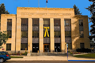
Gallatin County CourthouseThe Gallatin County Court House
Today, Gallatin County is the third most populous in Montana, and has been the fastest growing county for several years now. The outlying communities of Belgrade and Manhattan seem to have new housing developments springing up every time I pass by them on Interstate-90.

Bozeman and Gallatin County are home to the largest number of IT services in the state. They are also home to Montana State University and The Museum of the Rockies. The latter, while nominally a part of the University, is best known for being the child of paleontologist Jack Horner, himself known for his work with T. Rex skeletons found in Montana and for lending (or probably selling) his expertise to the Jurassic Park films.

On a literary front, Bozeman was home to Robert Pirsig when he wrote his Inquiry into Values, Zen and the Art of Motorcycle Maintenance. Bozeman is also, therefore, the starting point for the cross-country motorcycle trip that forms the framework of that book. On a personal note, I included Pirsig in my dissertation's bibliography, and if you have read the book and wonder what a cross-country motorcycle ride has to do with a fascist French novelist, then I beg you to go back and reread the book. It is one of the clearest explanations of the difference between the classical and the romantic mindset I've ever come across. Of course, you might not be interested in that particular difference. The book is still a great read about a trip by motorcycle. (But it's so much more, the little voice in the back of my aborted literature professor's head screams.)

The Bridger Mountains, as seen through the windows of the Montana Ale Works

The city of Bozeman sits in a dramatic setting at the foot of the Bridger Mountains. As you drive east across the city on Interstate 90, almost immediately after the last Bozeman exit, you start climbing toward Bozeman Pass and the county line with Park County (Number 49). I have long felt this stretch of I-90 is one of the most scenic drives in the state, but be prepared. I've been caught in blizzards on Bozeman Pass in June. The Bridger Mountains are also home to Bridger Bowl, one of Montana's premier ski resorts.

South of Bozeman, along the highway to the western entrance to Yellowstone National Park, sits Big Sky, a year-round resort originally begun by national newscaster Chet Huntley, a Montana native and MSU alumnus who returned to Montana after retiring from NBC news.

Even further south, in the southern-most point of Montana, sits the town of West Yellowstone, one of the five entrances to Yellowstone National Park. While most of the land area for the park is in the state of Wyoming, three of the park's five entrances are in Montana.

Grain Elevator in downtown Bozeman, Montana

Despite the Hi-Tech, Education and other businesses in Bozeman and Gallatin County, it is still a largely agricultural place. Population growth in Gallatin County, indeed across Montana, has led to disputes as the new-comers have both an idealized view of country living and often times big-city expectations. The Gallatin County Commissioners, taking their lead from western novelist Zane Grey, have put together a Code of the New West to help people adapt. It's a good read, and I recommend that anyone thinking of leaving the city for the country, whether in Montana or elsewhere, give it a read.

The U.S. Census counts and estimates show the rapid rate of growth here. The 1950 count indicated that there were 21,902 county residents. That grew 18.9% during the 50s to 26,045 in the 1960 count. The 1960s showed a growth rate of 24.8% with a 1970 count of 34,505. That number more than doubled by the 2000 census which showed 67,831 county residents, or 26 people per square mile in this 2,606 square mile county. While the 2010 numbers are not yet available, the increase shown in the 2008 census estimates indicate that the growth just continues, with a 32.4% increase from 2000 to 2008 and an estimated population of 89,824 in 2008, or a population that has more than tripled in the last sixty years.

Stained Glass in Pilgrim Congregational Church, Bozeman, Montana

The official website for Gallatin County can be found here, and the city of Bozeman has its site here.

Photo Information:

Gallatin County Sign:

Gallatin County Courthouse:

View of the Bridgers:

Grain Elevator:

Pilgrim Congregational Church Art:

Tuesday, April 13, 2010

5. Lewis and Clark County, Montana

5

Lewis & Clark County SignEdgerton County was formed in 1865, one year after Montana became a U.S. Territory. It was named for the first territorial governor, Sidney Edgerton. Edgerton, however, left Montana Territory and headed back home to Akron, Ohio, and in 1867 Edgerton County was renamed for the famed explorers, Lewis and Clark. Edgerton's life is a fascinating story, and he really deserves more credit that he is usually given, in that it was he who lobbied for the division of Idaho Territory and thus the creation of Montana Territory. Wikipedia has an article about him that is worth reading.


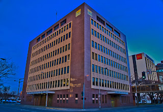
City-County BuildingThe City-County Building

Lewis and Clark County covers 3,461 square miles and is roughly 100 miles long north to south. The 2000 U.S. Census showed 55,716 county residents, giving it a population density of 16.1 people per square mile. The 2008 census estimate revealed a 9.3% growth, or 60,925. This puts the county in 6th place, state-wide. Most of the county's land area is rural, as is true for all of Montana. The county straddles the Continental Divide, and the northern reaches include much of the Bob Marshall Wilderness Area.

Cathedral of Saint HelenaThe Cathedral of Saint Helena

The county seat is Helena (pronounced with the accent on the first syllable). This pronunciation, which is a good way to tell whether someone is a Montanan or not, supposedly comes from the early miners who thought it was a helluva name for a town. Indeed, like much of western Montana, Helena got its start as a mining camp when the Four Georgians struck gold at Last Chance Gulch. This placer area was so rich that even today, the main street in downtown Helena is named Last Chance Gulch. By 1900, Helena had more millionaires per capita than any other US town. This is reflected in the magnificent homes that still exist on the west side of town.

Helena itself sits right on the southern edge of Lewis and Clark County, and lower taxes in neighboring Jefferson County (number 51) have meant that much of the regional growth has been in the southern neighbor, as Jefferson County became a bedroom community for Helena and was one of the fastest growing counties in Montana during the 80s and 90s.

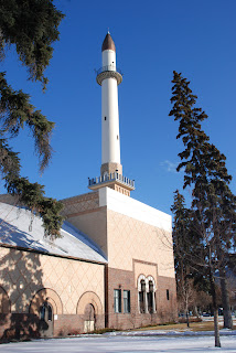
Civic CenterThe Civic Center

Helena is the only place in Montana to have a minaret, and that's on the building now used as the Civic Center. Built by the Shriners in 1920, the facility was given to the city and is now used for a wide variety of events. Last spring, after my employers hosted a conference on the Middle East, I drove a group of these visiting academics around western Montana. When we stopped at the Civic Center, I learned that the building is such a mish-mash of styles that no one knowledgeable in Arabic art and architecture would ever mistake it as one of their own. Who knew?

Sunset on the RockiesEvening in the Rockies

Montana is very active seismically, the fourth most active state in the U.S. As a rule, we don't get the big ones that folk in California, Alaska and Hawai'i fear, but every now and then.... A quake in 1935 did great damage to Helena, including major structural damage to the Cathedral of Saint Helena. The pictures collected by the University of Utah's Seismograph Stations show how badly the city was hurt.

Much of the arable land in the county sits along the Missouri River which flows in a northerly direction across the county, and is tapped for irrigation, power and recreation through three dams and their reservoirs located within fifty miles of Helena. Holter Dam, Hauser Dam, and Canyon Ferry Dam all harness the power of the Missouri and serve Helena and the Helena Valley. North of Helena, the river flows into a canyon in the Big Belt Mountains. This picturesque landscape caused Lewis and Clark to name it "The Gates of the Mountains." It is in this same area that in August, 1949, thirteen young firefighters lost their lives in the Mann Gulch fire. Norman Maclean, who wrote so eloquently about Missoula, fishing and religion in A River Runs Through It, has written equally eloquently about the fire in his book Young Men and Fire.

More information about Helena and Lewis and Clark County is available through their respective web sites and those of the Helena Convention and Visitor's Bureau and the Montana State Travel Site.

Photo Information:

Lewis and Clark County Sign: Taken 3/26/2010. Nikon D80 DSLR, Nikkor 16-85 mm lens set at 78 mm. ISO 125, f /16.0, 1/8 second. Finished in Photoshop CS4.

City-County Building: Taken 2/21/2010. Nikon D80 DSLR, Nikkor 16-85 mm lens set at 18 mm. ISO 125, f /19.0, 1/90 second. Finished in Photoshop CS4.

Cathedral of Saint Helena: Taken 3/14/2010. Nikon D80 DSLR, Nikkor 16-85 mm lens set at 26 mm. ISO 125 , f /11.0, 1/45 second. Finished in Photoshop CS4.

Civic Center: Taken 3/7/2009. Nikon D80 DSLR, Sigma 18-50 mm lens set at 25 mm. ISO 400, f /11.0, 1/500 second. Finished in Photoshop CS4.

Evening in the Rockies: Taken 3/26/2010. Nikon D80 DSLR, Nikkor 16-85 mm lens set at 70 mm. ISO 125, f /16.0, 1/60 second. Finished in Photoshop CS4.

Sunday, April 4, 2010

4. Missoula County, Montana

4

Missoula County Sign
Missoula County is one of the original nine counties of Montana Territory. In 1864, when Montana Territory was created by dividing Idaho Territory, Missoula County covered most of the land west of the Continental Divide. Today, seven counties have been formed from the original Missoula County.


Missoula County Court HouseThe Missoula County Court House

The city of Missoula sits in a natural bowl, geologically the bottom of Glacial Lake Missoula. If you know where to look, you can see the shoreline still visible on the hills that surround the city. I knew that the lake was large, but reading about it in preparation to writing this blog, I learned that it was larger than two of the Great Lakes (Erie and Ontario) combined. That's a lot of water.

Today, Missoula is known as the hub of five valleys. The Clark Fork River flows in from the east through the Hellgate Canyon. Just east of town, the Blackfoot (sometimes called the Big Blackfoot) River flows into the Clark Fork. If you've read Norman Maclean's book A River Runs Through It, most of the fly-fishing took place on the Blackfoot. If you saw the Robert Redford movie, the part of the Blackfoot was played by the Yellowstone, another important Montana River. In town, Rattlesnake Creek flows into the river, and there is a sign marking the spot where Lewis (of the Lewis and Clark Expedition) camped on July 4, 1806. On the west side of town, the Clark Fork and the Bitterroot Rivers merge, and together, a much larger river flows west out of town, out of the county, and eventually out of the state. The Clark Fork is one branch of the mighty Columbia River, and it carries the largest amount of water out of Montana, more even than the Missouri.

I once heard an NPR commentator refer to Missoula as the largest U.S. city completely surrounded by the Rocky Mountains. There is no place in town where you can stand, look at the horizon, and not see the mountains rising before you.

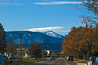
View of Lolo PeakView of Lolo Peak from Stephens Avenue, Missoula

The county extends roughly 30 miles west of the city, and borders Idaho County, Idaho at Lolo Pass. It reaches another 35 or so miles east of town, where it borders Granite County (number 46) on I-90 and Powell County (number 28) on Montana highway 200. The county is shaped like an irregular backwards capital "L" with the northern extension on the east side of the county. It reaches up through the Seeley/Swan Valley, caught between the Mission Mountains on the west and the Swan Range on the east. A chain of lakes lies in this valley which is a popular winter and summer recreation area.

Salmon LakeSalmon Lake in the Seeley/Swan Valley

For those of you who, like me, like data, Missoula County today covers 2,598 square miles, and with the 2000 US census count of 95,799 county residents, that meant 36.9 people per square mile. The 2008 census estimate showed 107,320 people living in the county, which puts Missoula County in second place after Yellowstone County. The two are the only Montana counties to have over 100,000 inhabitants.

Missoula is the home of The University of Montana, Region 1 of the U.S. Forest Service, and me. I moved to Missoula in 1975, and it's been home ever since. In fact, if mother's obstetrician had had his way, I would have been born in Missoula, but father had been transferred to near Billings, and mother insisted on going with him. Go figure. You can get more information on Missoula County and the City of Missoula by clicking on the links. Unlike Butte/Silver Bow, and Anaconda/Deer Lodge, Missoula city and county voters have turned down consolidation each time it has appeared on the ballot. Under Montana law, such issues must be revisited every ten years.

Photo Information:

Note that clicking on any photo will open it in a larger format and in a new window.

Missoula County Sign: Taken 3/26/2010 at the Missoula/Powell County line on Montana Highway 200. Nikon D80 DSLR, Nikkor 16-85 mm wide angle/tele/zoom lens set at 45 mm. ISO 800, f /16.0, 1/4 second.

Missoula County Court House: Taken 3/6/2010 in Missoula, Montana. Nikon D80 DSLR, Nikkor 16-85 mm wide angle/tele/zoom lens set at 18 mm. ISO 125, f /11.0, 1/500 second.

Lolo Peak from Stephens Avenue: Taken 11/15/2009 in Missoula, Montana. Nikon D80 DSLR, Nikkor 16-85 mm wide angle/tele/zoom lens set at 85 mm. ISO 800, f /9.5, 1/1500 second.

Salmon Lake HDR: Taken 10/2/2009 at Salmon Lake, Missoula County, Montana. Nikon D80 DSLR, Nikkor 16-85 mm wide angle/tele/zoom lens set at 25 mm. ISO 125, f /13.0, three separate exposures blended as an HDR image.

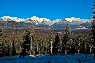
View of the Bob Marshall Wilderness: Taken 12/27/09 using a Nikon D80 DSLR fitted with a Nikkor 16-85 mm tele/zoom lens set at 85mm. This is a true HDR image processed in Photoshop CS4 with an ISO 125, f /16.0, and three consecutive exposures of 1/60, 1/250 and 1/1000 second. Camera was mounted on a tripod.


Looking east at the Swan Mountain RangeView across the Seeley Lake Valley at the peaks of the Bob Marshall Wilderness

3. Yellowstone County, Montana

3

Yellowstone County Sign
Yellowstone County was created on February 26, 1883, and by 1890 the US Census showed 2,065 people living in the county. Land for the county came from Gallatin, Meagher, Carbon and Custer Counties. While the county lines were changing pretty much constantly during the early years, in 1892, Yellowstone County covered over 6,000 square miles. By 1930, the census showed 30,785 county residents, which put the county in 3rd place at the time the county number scheme was implemented in 1934. Today Yellowstone County is the most populous county in the state, with a 2008 estimated population of 142,348 people, up 10% from the 2000 US Census count of 129,350. The land area today covers 2,635 square miles for a 2000 population density of 49.1 people per square mile. The county was named for the Yellowstone River which flows out of Yellowstone National Park and traverses the county flowing from southwest to northeast and serving as the principal source of irrigation water for the county's agriculture. The Yellowstone River in turn was named by the French trapper/explorers who misunderstood the indigenous Crow Indians. The Crow had always called the river the Elk River, but apparently in the Crow Language, Elk and Yellow Rock sound enough alike that the French were confused.


Yellowstone County CourthouseYellowstone County Court House

Billings is the county seat and Montana's most populated city. Founded in 1877 and incorporated in 1882, the city was named for Frederick Billings, then President of the Northern Pacific Railroad. Fifteen miles west of Billings is the town of Laurel where the Northern Pacific had their largest rail yard between Minneapolis and Seattle. The Billings/Laurel area is also home to numerous oil refineries, including ones run by Exxon/Mobile, Conoco/Phillips, and Cenex (Farmers' Union Central Exchange). Because the region outside of the Billings metro area is so sparsely populated, Billings serves as the commercial hub for eastern Montana, northern Wyoming and the western part of North Dakota.

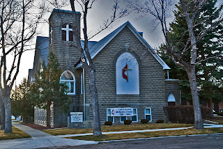
Laurel Montana United Methodist ChurchLaurel Montana United Methodist Church

In June, 1949, when my mother was 4 months pregnant with me, my father was transferred to the yoked parish of Laurel and Park City. I was born in October in the Billings Deaconess Hospital. (A Deaconess is a type of Methodist nun, largely active as nurses and teachers. Today, with female clergy the norm in the United Methodist Church, the order of Deaconess has all but died out.) While my father served the Laurel parish, it was separated from the Park City parish, and a new physical plant was constructed (shown above). My father was always proud that the church burned the mortgage 2 years and 9 months after breaking ground for the new church structure. The sanctuary seats 700, and the first service in the new building had standing room only.


Billings Chamber of Commerce Building DetailDetail from the original Billings Chamber of Commerce Building

Despite the modern look of the court house, Billings and Yellowstone County have many lovely older structures, including the original Billings Chamber of Commerce building located across the street from the Court House. Built in 1910 as the Elks Lodge, the building was sold to the precursor of the Chamber of Commerce, who continued to use the building into the 1960s. Threatened with demolition in the early 70s, and again in the 90s, the building still stands today and is listed on the National Register of Historic Places.


Despite being the most industrialized county in the state, Yellowstone remains predominately agricultural. Livestock sales in the county ranked #1 in the state in 2004, and principal crops include wheat, barley, corn and sugar beets. The land is dry and farmland has to be irrigated for production to succeed. The main landscape feature is the sandstone bluffs on either side of the Yellowstone River. Rising above the northern edge of the city of Billings, the Rimrocks form a natural barrier to expansion. Logan Field, the Billings airport, sits on top the bluffs, and should you fly into town, you may be surprised when your plane lands without seeming to descend from the clouds. As you approach the airport, you look down on the city and magically you're on the ground.

Billings is home to Montana State University-Billings, formerly known as Eastern Montana College, and to Rocky Mountain College, a private 4-year school jointly owned by the Congregational Church (UCC), the Presbyterian Church and the United Methodist Church.

Photo Information:

Note that double clicking on any image will open that image in a larger format on a new screen.

Yellowstone County Sign: Taken 3/25/2010 on the Yellowstone/Big Horn County line on Montana Highway 47. Nikon D80 DSLR, Nikkor 16-85 mm wide angle/tele/zoom lens set at 62 mm. ISO 125, f /11.0, 1/10 second. Finished in Photoshop CS4.

Yellowstone County Court House: Taken 3/24/2010 in Billings, Montana. Nikon D80 DSLR, Nikkor 16-85 mm wide angle/tele/zoom lens set at 16 mm. ISO 125, f /5.6, 1/8 second. Finished in Photoshop CS4.


Laurel United Methodist Church: Taken 3/24/2010 in Laurel, Montana. Nikon D80 DSLR, Nikkor 16-85 mm wide angle/tele/zoom lens set at 28 mm. ISO 125, f /11.0, 1/10 second. Finished in Photoshop CS4.

Detail of the Chamber of Commerce Building: Taken 3/24/2010 in Billings, Montana. Nikon D80 DSLR, Nikkor 16-85 mm wide angle/tele/zoom lens set at 24 mm. ISO 125, f /5.6, 1/4 second. Finished with a water color filter in Photoshop CS4.

Yucca Plant: Taken 3/25/2010 off Montana highway 47. Nikon D80 DSLR, Nikkor 16-85 mm wide angle/tele/zoom lens set at 85 mm. ISO 125, f /11.0, 1/10 second. Finished in Photoshop CS4.

Friday, April 2, 2010

2. Cascade County

2

CASCADE COUNTY HIGHWAY SIGN
Cascade County, number 2 on Montana license plates, was formed by a legislative act on September 12, 1887, two years before Montana Territory was admitted as a state. The county was formed from land taken from Chouteau, Lewis and Clark, and Meagher Counties. Both the county and its seat, Great Falls, are named for the series of waterfalls on the Missouri River that blocked Lewis and Clark on their upriver travel in 1805, forcing them to portage around "the thundering great falls." Bonds were sold for construction of the county's court house in 1901, and over the next two years, the building still serving was built--coming in over budget, of course. Originally the dome was to be of stone, but in the end, copper was used instead. The rest of the building is made of locally quarried sandstone.


CASCADE COUNTY COURT HOUSECascade County Court House (1901-1903)

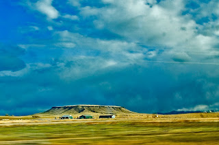
Long Montana's number 2 city, by 2000 Great Falls had fallen to third place after Billings and Missoula, and Cascade County to fifth. The county lies east of the Continental Divide, and slopes down from the Rocky Mountain front into the rolling plains of north central Montana. The western edge of the county is still quite mountainous, with many isolated outcroppings such as the mesa shown here just north of the town of Simms, Montana.


MESA IN WESTERN CASCADE COUNTYMesa, western Cascade County

Great Falls was the home of artist Charlie Russell, and his studio has been preserved on the grounds of the C.M. Russell Museum. So important is Charlie Russell to Montana history, that most Montana cities have a CM Russell school and one of the required items on Montana license plates is Russell's signature buffalo skull, which is used on current standard plates to separate the county number from the vehicle number. Russell is also one of two artists enshrined in the U.S. Capitol's statuary hall. The Museum holds an art show and sale every year--an event that has become so popular that Great Falls now hosts three separate art auctions annually.

The Missouri River flows north across Cascade County, and the city of Great Falls has preserved much of the river front as park land. The view below shows the new (2010) Federal Court House that has been built on the banks of the Missouri.

MISSOURI RIVER AND NEW FEDERAL COURT HOUSEView across the Missouri River, toward the new (2010) Federal Court House

Historically Great Falls has served as a major transportation center, shipping grain out of central Montana on the Great Northern, the Northern Pacific, and now the Burlington Northern Santa Fe Railroad. It was the home of one of the Anaconda Company's smelters, and when ARCO, who had bought operations from the Anaconda Company ceased production statewide, five percent of Cascade County's population lost work. Great Falls is also home to Malmstrom Air Force Base, and the possibility of closing the base due to reductions in the US Armed Forces is a constant worry for local business and government alike.

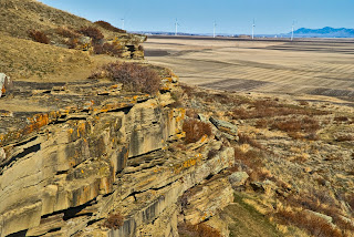
VIEW EAST FROM ULM PISHKUNView to the East from the Ulm Pishkun (Buffalo Jump)

The view above was taken at the Ulm Pishkun, now known as First People's Buffalo Jump, a state park located west of the city of Great Falls. In the photo above, we're looking east toward the city, a small windfarm located near the International Airport, and in the distance, the Highwood Mountains. Pishkuns, or Buffalo Jumps, are located all over Montana. They are places where a naturally occurring cliff allowed native people to lure buffalo to their death by stampeding them over the cliff. This allowed people who had no horses prior to the Spanish conquest of North America to gain food, clothing and shelter from the animal central to their very existence. Today the park has an interpretive center and good signage allowing us all to learn about this important aspect of native life.

The 2000 US Census showed 80,357 people living in Cascade County. This number, which had been relatively static since 1970, increased 2.1% by 2008 to an estimated population of 82,026. With a land area of 2,698 square miles, the 2000 census meant a population density of 29.8 people per square mile--most of them living within the city limits of Great Falls. Racially Cascade County is a good mirror of the state as a whole, with 90.6% of the population being white. There is a higher percentage of African Americans in Cascade County than state-wide, largely because of the airbase, and a lower percentage of Native Americans.

You can read more of my writing about Great Falls on my June 16, 2009 blog.

Photo Information:

Note that all photos will open in a larger format and in a new window if you double click on them.

Cascade County Sign: Taken 3/26/2010 at the Judith Basin/Cascade County line on Montana Highway 200. Nikon D80 DSLR, Nikkor 16-85 mm wide angle/tele/zoom lens set at 72 mm. ISO 125, f /16.0, 1/10 second. Finished in Photoshop CS4.

Cascade County Court House: Taken 3/14/2010 in Great Falls, Montana. Nikon D80 DSLR, Nikkor 16-85 mm wide angle/tele/zoom lens set at 22 mm. ISO 125, f /11.0, 1/90 second. Finished in Photoshop CS4.

Mesa: Taken 3/26/2010 near Simms, Montana. Nikon D80 DSLR, Nikkor 16-85 mm wide angle/tele/zoom lens set at 16 mm. ISO 125, f /16.0, 1/20 second. Finished in Photoshop CS4.

Missouri River and Federal Courthouse: Taken 6/13/2009 in Great Falls, Montana. Nikon D80 DSLR, Sigma 18-50 mm wide angle/tele/zoom lens set at 50 mm. ISO 125, f /5.6, 1/750 second. Finished in Photoshop CS4.

View from Ulm Pishkun: Taken 3/14/2010 near Ulm, Montana. Nikon D80 DSLR, Nikkor 16-85 mm wide angle/tele/zoom lens set at 85 mm. ISO 125, f /11.0, 1/125 second. Finished in Photoshop CS4.