3

Yellowstone County was created on February 26, 1883, and by 1890 the US Census showed 2,065 people living in the county. Land for the county came from Gallatin, Meagher, Carbon and Custer Counties. While the county lines were changing pretty much constantly during the early years, in 1892, Yellowstone County covered over 6,000 square miles. By 1930, the census showed 30,785 county residents, which put the county in 3rd place at the time the county number scheme was implemented in 1934. Today Yellowstone County is the most populous county in the state, with a 2008 estimated population of 142,348 people, up 10% from the 2000 US Census count of 129,350. The land area today covers 2,635 square miles for a 2000 population density of 49.1 people per square mile. The county was named for the Yellowstone River which flows out of Yellowstone National Park and traverses the county flowing from southwest to northeast and serving as the principal source of irrigation water for the county's agriculture. The Yellowstone River in turn was named by the French trapper/explorers who misunderstood the indigenous Crow Indians. The Crow had always called the river the Elk River, but apparently in the Crow Language, Elk and Yellow Rock sound enough alike that the French were confused.
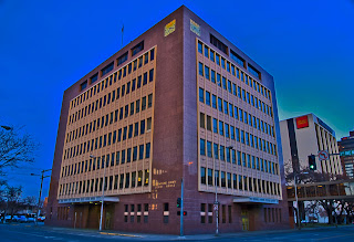
 Yellowstone County Court House
Billings is the county seat and Montana's most populated city. Founded in 1877 and incorporated in 1882, the city was named for Frederick Billings, then President of the Northern Pacific Railroad. Fifteen miles west of Billings is the town of Laurel where the Northern Pacific had their largest rail yard between Minneapolis and Seattle. The Billings/Laurel area is also home to numerous oil refineries, including ones run by Exxon/Mobile, Conoco/Phillips, and Cenex (Farmers' Union Central Exchange). Because the region outside of the Billings metro area is so sparsely populated, Billings serves as the commercial hub for eastern Montana, northern Wyoming and the western part of North Dakota.
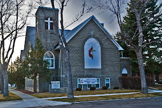
In June, 1949, when my mother was 4 months pregnant with me, my father was transferred to the yoked parish of Laurel and Park City. I was born in October in the Billings Deaconess Hospital. (A Deaconess is a type of Methodist nun, largely active as nurses and teachers. Today, with female clergy the norm in the United Methodist Church, the order of Deaconess has all but died out.) While my father served the Laurel parish, it was separated from the Park City parish, and a new physical plant was constructed (shown above). My father was always proud that the church burned the mortgage 2 years and 9 months after breaking ground for the new church structure. The sanctuary seats 700, and the first service in the new building had standing room only.
 Detail from the original Billings Chamber of Commerce Building
Despite the modern look of the court house, Billings and Yellowstone County have many lovely older structures, including the original Billings Chamber of Commerce building located across the street from the Court House. Built in 1910 as the Elks Lodge, the building was sold to the precursor of the Chamber of Commerce, who continued to use the building into the 1960s. Threatened with demolition in the early 70s, and again in the 90s, the building still stands today and is listed on the National Register of Historic Places.
Despite being the most industrialized county in the state, Yellowstone remains predominately agricultural. Livestock sales in the county ranked #1 in the state in 2004, and principal crops include wheat, barley, corn and sugar beets. The land is dry and farmland has to be irrigated for production to succeed. The main landscape feature is the sandstone bluffs on either side of the Yellowstone River. Rising above the northern edge of the city of Billings, the Rimrocks form a natural barrier to expansion. Logan Field, the Billings airport, sits on top the bluffs, and should you fly into town, you may be surprised when your plane lands without seeming to descend from the clouds. As you approach the airport, you look down on the city and magically you're on the ground.
Billings is home to Montana State University-Billings, formerly known as Eastern Montana College, and to Rocky Mountain College, a private 4-year school jointly owned by the Congregational Church (UCC), the Presbyterian Church and the United Methodist Church.
Photo Information:
Note that double clicking on any image will open that image in a larger format on a new screen.
Yellowstone County Sign: Taken 3/25/2010 on the Yellowstone/Big Horn County line on Montana Highway 47. Nikon D80 DSLR, Nikkor 16-85 mm wide angle/tele/zoom lens set at 62 mm. ISO 125, f /11.0, 1/10 second. Finished in Photoshop CS4.
Yellowstone County Court House: Taken 3/24/2010 in Billings, Montana. Nikon D80 DSLR, Nikkor 16-85 mm wide angle/tele/zoom lens set at 16 mm. ISO 125, f /5.6, 1/8 second. Finished in Photoshop CS4.
Laurel United Methodist Church: Taken 3/24/2010 in Laurel, Montana. Nikon D80 DSLR, Nikkor 16-85 mm wide angle/tele/zoom lens set at 28 mm. ISO 125, f /11.0, 1/10 second. Finished in Photoshop CS4.
Detail of the Chamber of Commerce Building: Taken 3/24/2010 in Billings, Montana. Nikon D80 DSLR, Nikkor 16-85 mm wide angle/tele/zoom lens set at 24 mm. ISO 125, f /5.6, 1/4 second. Finished with a water color filter in Photoshop CS4.
Yucca Plant: Taken 3/25/2010 off Montana highway 47. Nikon D80 DSLR, Nikkor 16-85 mm wide angle/tele/zoom lens set at 85 mm. ISO 125, f /11.0, 1/10 second. Finished in Photoshop CS4.

 Yucca with dried pods

2 comments:
Bryan ... you have done a stellar job on this wonderful piece! My thanks to your single handed effort to capture the History of Montana!
Hank
Gorgeous photography and very informative
Post a Comment