Showing posts with label Beaverhead County Montana. Show all posts

Tuesday, June 9, 2009

He Took Her For A Swan--Part II

Upper Red Rock LakeReeds growing in Upper Red Rocks Lake

Taken 6/6/09

Beaverhead County, Montana

NOTE PLEASE: Clicking on any photograph will open a full-screen version of that photo in a separate window. All links also open in a separate window.

Dell, a wide spot on the road, sits at Interstate 15's exit 23 in southern Beaverhead County, Montana. If you take the exit and turn east, you will find yourself face to face with an old school house (built 1903). The building is surrounded by buggies and wagons, including the shell of a sheepherder's wagon, and is festooned with ornamental lights and a sign reading "Dell Calf-A." You see, nowadays it's a restaurant. The café (or calf-a) is my favorite place to stop for a bite along I-15. Used to be service was family-style, with heaping trays of meat and veggies being passed down the long tables. These days, Health Department rulings don't allow that. Sit down, order your own meal, eat it, pay and leave. Of course, you might end up sitting down the table from a complete stranger, and you might end up having quite a conversation with that stranger. That's what happened when Kevin and I stopped for lunch, last Saturday.

You'll remember that we were on our way to the Centennial Valley, an area I thought to be north and west of Dell but which turned out to be south and east. I had my camera along and Kevin had one of his ham sets in the Saab. The weather hadn't let us put the top down, but we'd been tooling along at a good clip and the Saab was sipping its fuel instead of the pickup or Expedition gulping it. Kevin had just finished up a conversation with a painter from Arkansas who was looking to spend his summer in the Butte, Montana area. He too was headed for the Dell Calf-A, and suggested we look him up once we reached the restaurant. Such things happen when you're a ham operator--or so I'm learning. Kevin's call sign, by the way, is W1KGK, or Whiskey One, KGK, as my good Mormon boyfriend puts it.

As it turns out, we didn't meet the painter, but did end up sharing a table with a Canadian who has traded long-haul trucking for traveling North America on a Honda Gold Wing. We started talking about dogs--he has a Shi Tsu--and ended up talking about road trips. He was heading south to California, then up the coast. Personally, I'd rather do it a convertible, but to each his own.

Leaving Dell, we continued south to Monida, exit 0, and turned east. The pavement ended rather quickly, and the road sign indicated that we had 28 miles to cover before we would reach Lakeview. The road was fairly well maintained, and Kevin was able to keep the speed around 40 mph as we crossed mile after mile with nothing but grassland to see. There were mountains on the horizon, but the clouds were low enough that we could see their sides only intermittently and the peaks almost never. Listening to conversations on the ham set we kept hearing about the possibility of snow. This is Montana, after all.

Kevin braked abruptly and indicated that I should look to the left. Sure enough, there was a small herd of pronghorn just off the road. Of course, being rather skittish animals, as soon as I climbed from the car, the beasts turned tail and ran. I did get some shots of fuzzy looking animals at a distance, but nothing I'd care to share here.

Continuing on toward Lakeview and the Red Rock Lakes, we passed several groves of paper birch. I don't think I've ever seen so much paper birch before--beautiful trees. We drove through Lakeview, and on to Upper Red Rock Lake where we stopped for a potty break and some photography. Unfortunately, the wind was blowing so strongly that none of my macro shots turned out--the plants were moving faster than the shutter. I did see (and shoot) a couple of ducks swimming in the lake, and the shot of reeds in the water shown at the top of this page.

Snowslide above the Red Rock LakesSnowslide
Taken 6/6/09
Upper Red Rock Lake, Beaverhead County, Montana

Turning away from the lake, I saw this snow slide, and shot it. Later I got another shot of it from the other side of the lake. You'll note that the peak is lost in the clouds. There is a campground at Upper Red Rock Lake, and I'd like to come back later in the summer with the camper, the canoe, and my sailboard. I'll have to check if windsurfing is allowed, as the signs indicated canoeing only.

Driving on toward the east, we passed the end of the lake, and the road turned north. Soon we reached a decision point--turn to the west and drive along the northern boundary of the refuge, or toward the east and cross over into Idaho to pick up US 87. We turned west and quickly found ourselves driving through sand dunes. The Saab handled the sandy road quite well, but had the sand been any deeper, who knows.

At one point I had Kevin stop so I could try and get the grouse that were rising from the grass. No matter how stealthily I stalked, I never succeeded in getting any shots of the grouse. And the one time I thought I might get them, all that showed in the photograph was grass. Oh well. It was soon after this failed experiment that we came across the pronghorn who so graciously posed for the shot in the first Beaverhead County post.

Soon enough, we reached another decision point. 17 miles back to Monida and Interstate 15, or 55 miles to Alder and Montana highway 287. We chose the latter. In no time at all we were climbing a steep mountain road, through intermittent rain and snow, and the road was getting worse and worse.

When the car started sliding from side to side, I begged Kevin to slow down, but he replied "In mud, momentum is your friend." I tried to remain calm and held on for dear life, repeating my mantra "Today is a good day to die."

What seemed like hours later, we topped the crest and started our descent on a much better maintained Madison County road. Beaverhead County is so large, with so many back roads, that there just isn't the money to go around. Madison County is no richer than Beaverhead, but it isn't as large either.

Buffalo not roamingBison, definitely NOT roaming
Taken 6/6/09
Ruby River Ranch, Madison County, Montana

As we continued our descent, we passed the Ruby River Ranch and its herd of bison. These bison were definitely not roaming, but they didn't seem too perturbed by the electric fence, either. We also encountered some traffic on the road--much more vehicular traffic than I would have expected, but some wildlife, as well. This pronghorn seemed determined to set the pace as he trotted along in front of us.

an antelope not playingWell, if the buffalo aren't roaming, the antelope surely are
Taken 6/6/09
Madison County, Montana


Eventually we found ourselves following the upper stretches of the Ruby River down toward civilization. This is another area where I want to park the camper. My friend Rick and I camped by a small hot-springs fed pond on the west side of the Ruby River Reservoir many years ago, and I'd love to go back. This is the home for Montana's second Territorial Capitol, Virginia City, which, unlike Bannack, only looks like a ghost town. In reality it's the county seat of Madison County and in the summer time it hosts numerous tourist events. I love to go see the Brewery Follies, a sort of home-grown Capitol Steps type review of political song and satire. If you're more into the Olde Time Melodrama, you can get that every evening at the Opera House. There are staged shoot-outs on the main street, and lots of tourist kitsch to keep everyone happy.

This trip, however, we needed to get home to shoot the dog, er give Rocky his insulin injection, so we turned west, driving through Sheridan, Twin Bridges, Butte, Deer Lodge and Drummond, to get home only a little late for Rocky's evening medication.

While I can't recommend taking a sports car through the roads we traveled, if you're up for some adventure, lots of incredible scenery, and more wildlife than you can shake a stick at, you can't beat Montana's Beaverhead and Madison Counties.

If you read my first post on this subject, you may recall that the intent was for me to get some great shots of Trumpeter Swans. Well, even though the brochure we picked up at Upper Red Rocks Lake states that the swans are common all four seasons of the year, this trip we saw nary a one. Not a single swan appeared to pose for my camera. Not one! I guess we'll have to go back.

the Upper Ruby RiverThe upper Ruby River
Taken 6/6/09
Madison County, Montana

As a final note, there were a couple of things deserving of photographic documentation that, like the swans, I failed to capture. First, in southern Madison County there is a stream named "Poison Creek." It has a road, the "Poison Creek Road" that is labeled, appropriately enough, "Dead End." Unfortunately the signs were facing in opposite directions, so I couldn't get a good juxtaposing shot. And speaking of shots, at "Vigilante Station," also in southern Madison County, there is a sign that reads "No shooting." Seems like a contradiction in terms to me.

He Took Her For A Swan

Pronghorn (Antilocapra americana)
Usually called (in error) Antelope
Taken 6/6/09
Centennial Valley, Beaverhead County, Montana

NOTE PLEASE: Clicking on any photograph will open a full-screen version of that photo in a separate window. All links also open in a separate window.

He roamed near the place where his true love was slain
He wept bitter tears, but his cries were all in vain.
As he looked on the lake, a swan glided by
And the sun slowly sank in the grey of the sky.

She'd her apron wrapped about her and he took her for a swan
But it's oh and alas it was she, Polly Von.

--Yarrow/Stookey/Travers- Pepamar Music ASCAP
For a youtube version of this song, click here.

Kevin promised me a swan. Actually, he promised me lots of swans. Trumpeter swans nesting in Montana's Centennial Valley. And it being the time of year it is, there might even be, probably would be, some cygnets as well--but I think he called them "baby swans." This was the day we were out on Brown's Lake, Memorial Day, that is, when I kept playing hide and seek with the Great Blue Herons. It just amazes me how such a large, ungainly bird can hide in a few reeds. I've posted the portrait of that GBH on Eyefetch, if you care to see how the match ended.

Friday evening (June 5th, 2009), I suggested to Kevin that I would not be averse to a road trip on Saturday--off to find the swans in the Centennial Valley. Mind you, I wasn't exactly sure where the Centennial Valley was, just that it's in Beaverhead County somewhere. What I did know was that Beaverhead County is Montana's largest county in area. If you look at Montana's border with Idaho as forming a face, Missoula, where I live, is in the eyesocket, Ravalli County where my cabin is located, is the nose, and Beaverhead County is the mouth and chin. It measures 5,572 square miles, and the 2000 census shows a population of 9,202 people, over 95% of whom are white. Of those nine thousand folk, 3,752 live in the county seat, Dillon. That leaves 5,450 folk spread out over the landscape, or less than one person per square mile. Looking at it another way, Beaverhead County is larger than the state of Connecticut, and considerably larger than Rhode Island and Delaware combined.

Less than 1 person per square mile Taken 6/6/09 Centennial Valley, Beaverhead County, Montana

Driving north on Interstate 15, you enter Montana at Monida Pass which separates Clark County, Idaho, from Beaverhead County, Montana. I have driven I-15 many times, in both directions, and knew that part of the county traversed by the interstate. I have visited Dillon on numerous occasions, as well as the area north and west of Dillon, specifically the Big Hole Valley which I wrote about last September. The Big Hole Valley is so large that quite frankly I ignored the rest of the county. When Kevin talked about the Centennial Valley, I thought we were headed to Clark Canyon Reservoir which sits alongside I-15 south of Dillon. Live and learn.

Our favorite local weatherman (and fellow Bass in the Missoula Gay Men's Chorus), Mark Heyka, had forecast flooding in the southern Bitterroot, and I woke to very gray skies on Saturday morning. Oh well, when you're trying to photograph nesting birds, overcast skies are not a bad thing. Kevin surprised me by getting up all bright eyed and bushy tailed at 6:30. Shower, dress, give Rocky his morning insulin shot, and we headed out the door. Kevin had already installed a ham radio outfit in the Saab, and I added my camera bag and a change of clothes--in case I got soaked while hunting the swans. What neither of us thought to throw in the car was road food.

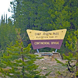
Driving up the Bitterroot on US 93 (which in old-tyme Montana terms means driving South), we watched the river flowing nearly bank-full, but didn't see much flooding. As we approached the Idaho state line at Lost Trail Pass, we turned east on Montana 43 and crossed the Continental Divide at Chief Joseph Pass. At 7,264 feet, Chief Joseph Pass is the home of one of my favorite cross-country skiing areas. I pulled into the ski area parking lot, and headed for the outhouse. Once seated on the throne, I looked over at the opposite wall and called for Kevin to bring me my camera. I mean how often do you get to take the portrait of two large daddy-long-legs (I think Harvestmen, not Cellar Spiders) on a plain white background. Unfortunately, Kevin brought me the camera, but not the bag, so I was stuck with the long macro lens and had to take the portraits from across the room. (Yes, I know, I could have gone to get the bag and changed the lens--hindsight is 20/20 after all.)

Driving down Montana 43 into the Big Hole, I asked Kevin to stop alongside Trail Creek. As often as I have driven this stretch of road, I have always promised myself that I would get some shots of the rail fences that front the road. Shooting not just the fence, but also the creek and some of the nearby rock formations, I marveled at the fact that this small stream was on its way to become the mighty Missouri River.

Trail Creek with Rail Fence
Taken 6/6/09
Near Chief Joseph Pass, Beaverhead County, Montana

Back in the car, I next directed Kevin to stop at the Big Hole National Battlefield. I always get the chills when I stop at the Battlefield. The landscape looks so peaceful, but the battle was so fierce between the US Cavalry and a group of people who only wanted to continue to live their lives in peace. I've written about the battle before in the blog referenced above.

Leaving the park (Big Hole National Battlefield is now part of the Nez Percé National Historical Park), I caught sight of some wildlife, and had Kevin stop and roll down his window. I leaned across Kevin aiming my camera out the driver's side window. The gopher practically posed for me, even though Kevin never saw what I was photographing. When you're looking for wildlife to photograph, you take what you get.

Big Hole Battlefield
Nez Percé National Historical Park
Taken 6/6/09
Near Wisdom, Montana

Heading further east on Montana 43, we approached Wisdom--the town that is. There were several antelope in the fields with the cattle, but Kevin didn't stop promising that there would be plenty of antelope (OK, pronghorn) when we reached our destination. So now he's promising me both swans and antelope. Hmm, if we run into buffalo (bison) and deer, we can have quite a song fest.

At Wisdom, we turned south on Montana Secondary 278 heading toward Jackson. Past Jackson, and its famous Hot Springs, we turned off 278 to visit Bannack, Montana's first territorial capital. It has never made sense to me that Bannack would be chosen as a capital, especially as it's located in the relatively empty southwestern corner of a rather large, and still relatively empty, state. Today the ghost town is a state park, and the caretaker informed me that back in 1864 when Montana Territory was created out of Dakota Territory (east of the continental divide) and Washington Territory (west of the divide), the gold camp of Bannack was one of the largest settlements in the area. OK, I'll have to accept that, but it still seems a bit bogus to me. Still and all, the area is rich in history and apparently the state has found some money to put into the park, because the place looked a lot better than I remember it. Kevin and I wandered through the "town" and I got several interesting shots, including a bunny just outside the old jail. More wildlife to capture, I tell you.

Retired Red Pickup
Taken 6/6/09
Bannack, Montana


We left Bannack, driving south on the Bannack Bench Road, heading toward the Horse Prairie country. This is the land to the west of Clark Canyon Reservoir, and I was still thinking this was the Centennial Valley. We drove through the Horse Prairie, past Clark Canyon, and stopped for lunch at my favorite I-15 wide spot in the road, the Dell Calf-A. As this post is getting a bit wordy, and we have just stopped for lunch, I'll stop for now and take up the drive in my next posting.

Specifics:
Left Missoula 6:30 a.m.
Arrived Missoula 8:15 p.m.
Total Miles 500+
Counties traversed: Missoula, Ravalli, Beaverhead, Madison, Jefferson, Silver Bow, Deer Lodge, Powell, and Granite.
Photos taken 125
Click on the picture below to be taken to the album/slideshow. (100 photos, mostly unedited)
20090606


And if you just haven't had enough music going through your head yet, let me recommend that you visit my on-line friend Michael's blog: The 007 GentleMan Blog: Afternoon Delight

Thursday, September 11, 2008

Twin Lakes--Reflecting the Big Sky

Twin Lakes, Beaverhead County, Montana
Taken 9/6/08


I’d like to say a word for the cowboy.
The road he treads is difficult and stony.
He rides fer days on end with jist a pony fer a friend.
I sure am feelin’ sorry fer the pony.

--Oscar Hammerstein II


Beaverhead County is Montana’s largest in area and last Saturday, September 6th, we drove most of it. Well, not really, but when you’re driving over Forest Service Roads at five to ten miles per hour for four hours it sure feels like you’re never gonna get home again. Between the rocks and the ruts, the truck bounced and jittered, and the camper swung back and forth so violently, that I feared the truck bed would separate from the cab or the weight of the camper would have us on our side.

Admittedly, my DeLorme Montana Atlas bears a 1994 copyright, but do roads just disappear? Our friend Stan had the same atlas, but with a 2001 copyright, and his showed the same roads. Both books claimed we were on Forest Service Road 945.1, but all the signs said 944. And try as we might we could not find the connecting road that would get us to what my atlas named Road 12. Stan’s atlas called it Road 945.2. Maybe that should have told us something.

Our friends Stan and Leon live on top of a ridge near Stevensville, Montana. Whenever they can, they like to put their canoe on top the Jeep and head out for some fishing and canoeing. I had mentioned that if they ever wanted company, they should let us know. Thursday, September 4th, Leon sent me an e-mail saying that they were planning on spending the upcoming weekend at Twin Lakes in the Big Hole Valley. While I’ve spent lots of time in the Big Hole, I’d never been to Twin Lakes.

Kevin had, as he grew up in Beaverhead County, and when I started looking online for geocaches around the town of Wisdom, Kevin informed me that we wouldn’t be going anywhere near Wisdom. Now as I looked at the map, the only alternative to driving through Wisdom was to take a Forest Service road that followed the base of the mountains. Still I bowed to his experience and said “Drive on!” We met Stan and Leon at the supermarket in Stevensville, and they agreed to try our route, so the four of us took off on Captain Clark’s 1806 route through the Bitterroot and Big Hole Valleys.

On their return from the Pacific in 1806, Lewis and Clark’s Corp of Discovery camped at Traveler’s Rest, now a Montana State Park just a few miles south of Missoula. On July 3rd, the company split with Lewis heading north and Clark south. Lewis and his men spent July 4th on the site of what is now Missoula and sure enough, there is a plaque right downtown saying “Lewis slept here.” Well, maybe not in so many words, but that’s the jist of the message—and right in front of a motel, too.

Clark took his men and headed south, traveling up the Bitterroot River and crossing the Continental Divide at Gibbon’s Pass. You can read about the whole Lewis and Clark adventure here. And while we’re on the subject of Lewis and Clark, all Montana school children learn that the Corps of Discovery followed the Missouri River upstream to the point where three rivers come together—the site of present day Three Forks, Montana. We learn that the three rivers are named the Madison, the Jefferson and the Gallatin—named for the Secretary of State (and fourth US President) James Madison, President Thomas Jefferson, and Secretary of the Treasury Albert Gallatin. Wikipedia will even tell you that Lewis himself named the rivers on the way west in 1805. What isn’t so well known is that while traveling up the Jefferson, they came to another confluence of rivers which they named Philanthropy, Philosophy and Wisdom. Today we know these rivers as the Ruby, the Beaverhead, and the Big Hole. The Big Hole flows right past the town of Wisdom—the only place name where Lewis’s appellation still exists. (I hesitate to suggest that there is no philanthropy or philosophy in Montana.)

The Big Hole is also the site of one of the great tragedies of US history. In 1877, a band of Nez Perce Indians, led by Chief Joseph, fled their homeland in northeastern Oregon heading east. The US Government was determined to place all native peoples on reservations, and this group of Nez Perce resisted. They crossed the Idaho panhandle and entered Montana Territory at Lolo Pass. Like Clark, they traveled up the Bitterroot and crossed the Continental Divide into the Big Hole Valley. Believing themselves safe, they camped for several days in early August, only to be awakened by gunfire. The cavalry had arrived. Roughly one-tenth of the encamped Nez Perce were killed—men, women and children, but the survivors were able to force the US military to retreat. After the battle was over, the Nez Perce continued east, through Yellowstone Park then north across central Montana until they were finally stopped at the Battle of the Bear Paw, near present day Chinook Montana. The Nez Perce had traveled 1100 miles, fighting US forces the entire way. When captured at the Bears Paw, they were less than 40 miles from the Canadian border. Chief Joseph’s speech of surrender remains today one of the great pieces of American literature. It bears repeating in its entirety.

________________________________________

Surrender Speech In the Bear Paw Mountains
- October 5th, 1877
________________________________________

I am tired of fighting.
Our chiefs are killed.
Looking Glass is dead.
Toohulhulsote is dead.
The old men are all dead.
It is the young men who say no and yes.
He who led the young men is dead.
It is cold and we have no blankets.
The little children are freezing to death.
My people, some of them,
Have run away to the hills
And have no blankets, no food.
No one knows where they are-
Perhaps they are freezing to death.
I want to have time to look for my children
And see how many of them I can find.
Maybe I shall find them among the dead.
Hear me, my chiefs, I am tired.
My heart is sad and sick.
From where the sun now stands
I will fight no more forever...

Hinmahtoo Yahlatkekeht of the Nez Perce
("Thunder Rolling in the Mountains." or "Chief Joseph")


I cannot visit the Big Hole Battlefield without choking up. Even today, as I write of these events, I feel my throat closing and my eyes filling. The only other places I’ve visited that have the same effect are Culloden Moor in Scotland, and the Gallipoli battlefields in Turkey. Even as a child, the Big Hole spooked me in a way that Montana’s other “famous” battlefield, The Little Big Horn, did not. As the bumper stickers say, “Custer had it coming.”

This weekend we were not stopping at the monument. We had driven up the Bitterroot on US 93, and turned east crossing the Continental Divide at Chief Joseph Pass. We drove into the Big Hole on Montana 43, turning off the highway just east of the monument.

Land of 10,000 Hay Stacks
Taken 9/7/08
Big Hole Valley, Montana

The dirt road ran in a southwesterly direction across the hayfields of the Big Hole Valley, known locally as the home of 10,000 hay stacks. Relatively smooth, as dirt roads go, our route was taking us toward Forest Service Land and the Continental Divide and Idaho. It was also supposed to take us to another Forest Service road that would connect up with the road to Twin Lakes. Or so both DeLorme and Kevin assured me.

Passing numerous groups of hunters out for the opening weekend of archery season, we followed a game warden right up to the point where he headed west toward Idaho and we turned south toward Twin Lakes. I wasn’t watching the odometer, but Leon tells me we’d traveled twenty miles from the highway when we finally gave up and turned around. Oh we didn’t want to give up, but our road had become two tracks, branches were breaking off as they scraped the camper, and there was a log down across the “road.” Somehow Kevin managed to get the F250 turned around without having forty acres, and we started back toward the highway.

Not the end of the road, but enough for us
Taken 9/6/08
Beaverhead County, Montana

Still believing our maps, we explored a couple of roads that forked off road 944, but in the first case, we came to a fence and a no trespassing sign, and in the second we found ourselves at an impassable irrigation ditch. Giving up, we returned past all the hunters and turned east on Montana 43. We were going to go through Wisdom after all.

The road to Twin Lakes was in better shape than Forest Service 944, but it was still a dirt road, and it was still slow going. This time, sixteen miles after turning off the pavement, we found ourselves at a beautifully maintained campground on the shore of the lower of the two lakes. We built a campfire and Stan and Leon set up their tent. As we were carrying our house on our back, or rather the truck’s back, Kevin and I just sat back and watched.

Twin Lakes sits below the mountains of the Continental Divide on the Montana side of the Montana/Idaho state line. At 7200 feet, the campground was higher than our last excursion—Pat’s Knob, but the weather was crisp and clear. The lakes looked inviting, but we decided that we’d wait until after dinner to get out on the water. Unfortunately, by the time we finished eating and cleaning up the campsite, it was too late to canoe.

I won’t speak for anyone else, but I slept well Saturday night, and when I awoke Sunday morning, Stan and Leon had a fire blazing and were off hiking along the lake. The water was glass smooth, and reflected the mountain scenery to perfection. As you look at the scenes in my Picasa gallery, you’ll assume that some of the photos are upside down. Nope, it just that I aimed at the water and not the sky.
Reflections in a clear blue lake
Taken 9/7/08
Twin Lakes, Beaverhead County, Montana

As we ate breakfast, clouds started moving in and the temperature dropped. Remembering how cold we had been on Monday, neither Kevin nor I were keen on getting out into the middle of the lake in a rain storm. As it turned out, Stan and Leon were just as happy to leave their canoe on top the jeep, so none of had a chance to glide cross that beautifully clear water. We all agreed that Twin Lakes was worth another trip—this time without exploring the National Forest’s back roads.

Typical Montana Ranch--what a view!
Taken 9/7/08
Big Hole Valley, Montana

On the way out, Kevin stopped frequently so that I could document the scenery. We had lunch at Fetty’s Café, in business since the 1930s, and this time I can really recommend a place. Kevin’s burger was moist and my salad and chili were fresh and tasty. The waiter was cute and with tip, our lunch came to $25.00. I’ll go back to Fetty’s.

And by the way, I found two of the three geocaches I was seeking in the Wisdom area. Can’t wait to get back over there.