Sunday, December 22, 2019

Merry Christmas 2019 and Happy New Year, 2020.


Merry Christmas 2019 and a Happy 2020 New Year to all family and friends, far and near.

It's been a while since I've written a Christmas letter, but for some reason it felt right to do it now.  Normally, I would open with either the first photo I took this year, or a photo of some religious scene I had noticed.  This afternoon, however, when I opened my January 1, 2019 photo collection, the image above jumped out at me.  It's a four photo panorama that I took at the National Bison Range, about forty miles east of home.  One of my favorite scenes, the Mission Mountains rise in the background.   This was not taken on January 1st.  I'm not sure how it ended up in the January 1st folder.  One of the joys of Lightroom, no doubt.  These four photos were actually taken on April 25th, 2019.  The image was so striking that I felt it would be a good place to start.  Below you can see the photo that really was the first one I took in 2019.  A view out over the Lower Clark Fork Valley just west of Plains.


Looks a lot more like January 1st, doesn't it.  It was taken in the later afternoon, so that helps to explain the darkness in the scene.

Mid January had things looking a lot more like winter.  This scene, shot out ouf front door on January 16th, gives you an idea of the snow and sun that Winter in Montana can bring.


 On February first, I captured this shot of the old Diehl Ranch which was being sold by the Lawyer's Nursery folk.  The farm is on the west side of Plains and is nestled into a big bend in the Clark Fork River.  The picture to me evokes a pastoral Christmas card feeling.


Judging by my photos, we didn't take any trips during February (other than our bimonthly visits to either Missoula or Kalispell).  Most of my February photos were of flowers here at home, either  orchids like the one above, or hibiscus which seem to bloom year round as long as I keep them warm and indoors.

March also provided a lot of floral photos, but we did some limited traveling.   A drive to Thompspon Falls allowed me to capture this view looking into Bad Rock Canyon between Plains and Thompson.

At the end of the month, I talked Kevin into taking me to Newport, Washington, then north along the Pend Oreille River almost to the Canadian border.  We stopped at the town of Metalline Falls, before turning back south and east to home.  One of the photos I took was this one of the Congregational Church in Ione, Washington.


April brought the first flowers blooming outdoors, the first of my surgeries this year, and the first CouchSurfing guest of the year whom I was pleased to serve as Tour Guide, taking him to Wallace, Idaho, the Center of the Universe, after all, Glacier National Park, and St. Ignatius, Montana, where we met some lovely people who host a monthly brunch potluck.  


Our (East) German guest at the Center of the Universe.  Or, does that sign mean that he's the Center of the Universe.  I'm so confused.


I consider this to be the best photograph I've ever taken in Glacier National Park.  Lake McDonald was so clear and calm.  Fiftenn minutes later, the wind had come up and this photo would have been impossible.  Still with our East German guest.


Early May had us take the back road home from Polson, crossing the Flathead River west of Ronan and driving into Hot Springs on the Little Bitterroot Road where we found this group of very pretty horses (and mules).  Late May brought us another house guest, this time through Warm Showers, and he was riding the route of the great draining of Glacial Lake Missoula.  Of course we had to go tothe Bison Range and see the Lake Missoula signage there.  Not to mention getting the chance to ask "Why did the bison cross the road'?


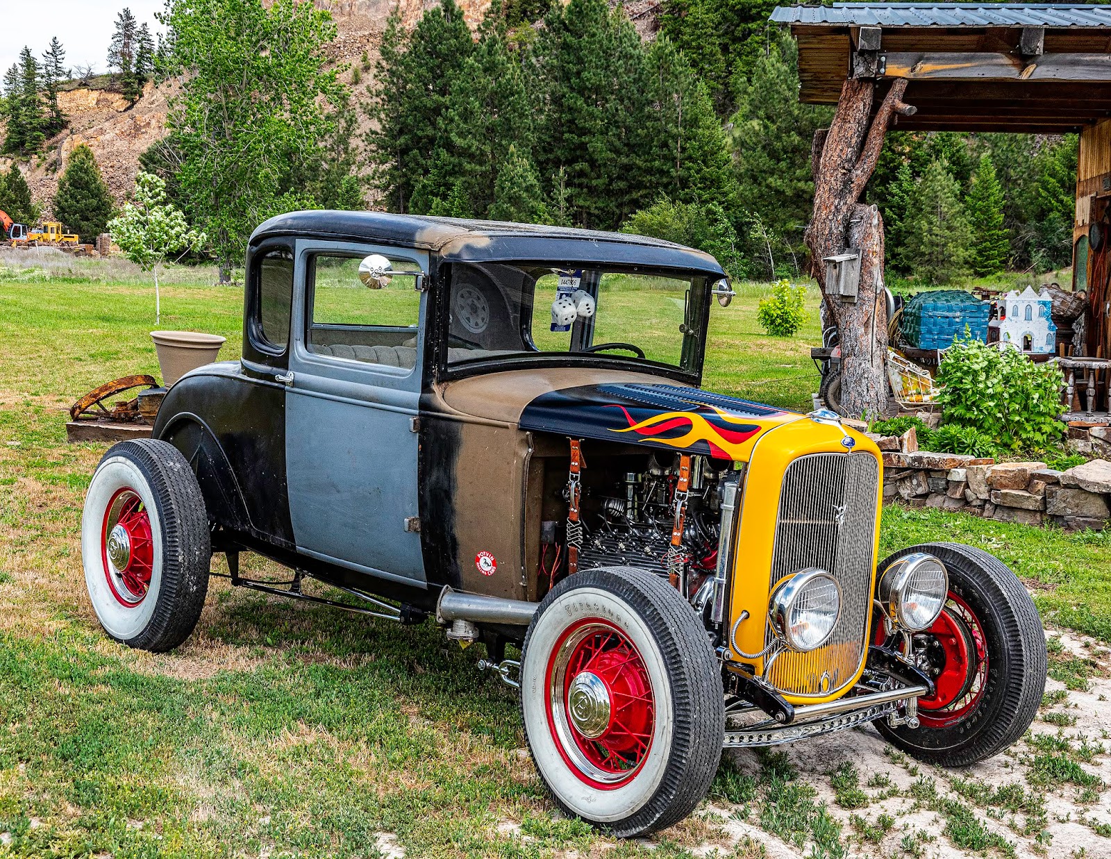
June brought car show season to Plains, starting with the Rehbein Ford sponsored Plains Day Car Show on June 1st.  I took a raft of photos, but missed a few and had to look up the owners.  One such, who wishes to remain nameless, actually took me for a ride in his hot rod.  In exchange, I gave him a portfolio of photos I took of his car.  What a hoot!
                      

June also gave me the chance to work on my photoshop skills by isolating this gorgeous white iris growing in our garden.  I do love my flowers.


That's enough for now.  You've seen what the first half of 2019 threw at us.  Looking back through the photos, it would appear that we did a lot more than I remember.  Guess that's why I take the photos

Second half the year to come.  Stay tuned.  Don't touch that dial!  (Does anyone today rememger a "dial"?

Love,

Bryan, for Kevin, Rocky, Digger and the Cat.


Wednesday, December 11, 2019

Instant Pot™ Cock-a-leekie Soup

Bryan's Instant Pot™ Cock-A-Leekie Soup

 Two days ago, Kevin roasted a small chicken in the oven.  It was delicious, but even though it was very small, there was still leftover chicken.  I could have made a salad, but we are living with soup weather, and since I had a portion of a leek left over as well, I thought, "Why not make Cock-a-Leekie Soup?"  Now understand, I have never made this particular soup before, so I wasn't sure just what to expect, but chicken soup is good, right?  And I like leeks, so what could go wrong?  As it turns out, nothing.

I wanted to make the soup in the Instant Pot™, so I looked up a recipe on line, just to be safe.  If you want to try the original recipe, you can find it here on eatathomecooks.com  If you'd like to try my Yes I Used Leftovers recipe, here it is.  Now I don't know about you, but if I'm going to be eating delicious home-made soup, I want some equally delicious home-made bread to go with it.  In this case, I made baguettes following Dan Leader's recipe for 4-Hour Baguettes.  I've made this recipe several times, and it's never failed me.  Rather than type it out, I'll just send you to the on line site where I found it, Food52.com.  You may have to sign up for a Food52 membership, but it's free and well worth the time.


One and a quarter baguettes
RECIPE:

Bryan's Instant Pot™ Cock-A-Leekie Soup

Prep time:  5 minutes, depending on what you have in the fridge

Pressure Cooker Time:  15 minutes under pressure, plus 12 minutes release time (and of course, however much time it takes your pressure cooker to come up to pressure).

Servings:  I don't know.  How hungry are you?  Are you one of those people who think that 1 pint of Ben and Jerry's is a single serving?  The original recipe claims that it serves 8.  I eat more than they do.

Ingredients:


  • Left over shredded chicken ( I had about 2 cups)
  • 1 1/2 leeks, chopped  and cleaned
  • 5 carrots, pared and chopped
  • 1/3 cup pearl barley
  • dash onion powder
  • 1 bay leaf
  • dash of dried thyme
  • 2 quarts chicken broth (I used Better Than Bouillon mixed in hot water)
  • Salt and Pepper to taste (I forgot to add this, but Kevin added it after cooking)
  • Dried prunes, diced, for topping, optional
Instructions:

  1. Place chicken in the Instant Pot™
  2. Add leeks, carrots, barley,  herbs and spices to the pot.
  3. Pour broth over all ingredients and stir to make sure the Better Than Bouillon is well mixed.
  4. Set Pressure Cooker for 15 minutes.  When time is up, let it release pressure naturally for 10 minutes, the turn the valve to release remaining pressure.
  5. Remove lid and serve, adding the diced prunes if desired.
Now Kevin thought the prunes would not be a good idea, so he didn't add any.  I, on the other hand, wanted to check out just what they flavor they might add, so I chopped up about 5 small prunes and added that into my bowl.  Near as I could tell, they added a very small amount of sweetness to the soup, and I will add them again when I have the left over soup for lunch.

The baguette recipe, by the way, makes three nice sized baguettes, and at this point (10 am the next day), we have only one baguette left.  That's right, between Kevin and me, for supper last night and breakfast this morning, we already ate two of the baguettes.  Your mileage my vary.

And while I'm crowing (cock-a-leekie, get it?), let me tell you I just got the notification that one of my photographs has been chosen to appear in the January/February issue of Montana Outdoors, the magazine published by the State of Montana's Department of Fish Wildlife and Parks.  The picture they chose is shown below, and you can get your own copy of it by visiting my on-line sales gallery by clicking here at RedBubble.  I have chosen to show it as a Metal Print, but you can have it in any of a number of forms, including a mini-skirt, a clock, coffee mugs, or even a bath mat and shower curtain.  Just check out RedBubble.   And the photo itself?  One of my all-time favorite photographs, one that I took at South Sandstone Reservoir, south of Plevna in Fallon County, Montana, back in 2007.

South Sandstone Reservoir, Fallon County, Montana

Saturday, December 7, 2019

Instant Pot™ Potage St. Germain

It's December, and while technically it might not be Winter, the air is cool enough, and there is snow and ice around, so let's make soup.  One of my all-time favorite soups is Potage St. Germain, a French pea soup that I first met through the three volume Illustrated Good Housekeeping Encyclopedic Cookbook © 1965 where I found the recipe in volume 3 page 1190.  I've been making this soup for a very long time, always faithfully following the recipe and always loving the result.  But I have a new kitchen gadget (those of you who know me personally know I belong to the Kitchen Gadget of the Month Club), and frankly, I'm in love with my Instant Pot™.  I've had it just about a year now--it was Kevin's Christmas present to me in 2018, and I'm learning all kinds of new tricks with it.  Two days ago, for instance, I made a risotta in it.  Heaven.  No standing at the stove stirring for half an hour.

Anyway...  When I made the soup earlier in the week, I photographed a bowl and posted that on Facebook and Twitter where friends asked for the recipe.  Since I adapted the Good Housekeeping recipe for the Instant Pot™, here, to the best of my recollection, is what I did (and I have the Good Housekeeping recipe right in front of me as I write this).

Instant Pot™ Potage St. Germain


1 Tablespoon butter
1 medium onion, minced
1 medium carrot, pared and finely diced
The green part of a large leek, chopped or snipped
6 or so cups chicken  or vegetable broth
1 ham hock with some meat attached
1 cup shredded lettuce (or spinach--I used lettuce)
1 bay leaf
A few sprigs of fresh thyme (or a pinch dried thyme)
2 cups quick-cooking green split peas
Salt to taste
1 teaspoon sugar
2 Tablespoons Butter
1/2 cup heavy cream
1 cup shelled fresh or frozen peas (I used frozen)

--------------------------------------------------------------------------------------------------------------------------
1)  Set Instant Pot™ to Sauté and let heat up.
2) Melt the 1 Tablespoon butter in the hot pot, then add in the onion, carrot and leek.  Sauté for 3-4 minutes until the onion is translucent and the carrot and leek has softened.
3) Pour in the stock, add the shredded lettuce, the bay leaf, the thyme, the 2 cups split peas,  the ham hock, salt (and I add fresh ground pepper), and the sugar.  Close top and set vent switch to pressure.   Set the Instant Pot™ to High Pressure and set timer for 7 minutes.  WAIT (It will take approximately 10 minutes for the pot to come up to pressure.)
4) When the Instant Pot™'s timer has counted down the 7 minutes, let the pressure release naturally for 5 minutes, then move the vent switch to release any remaining pressure.
5) When you remove the lid,  remove the bone and if you wish you may use an immersion blender to blend all those veggies, but I don't.  I find the pressure cooking does a pretty good job of mixing everything up.
6) While the soup is still hot, add the frozen peas, the 2 Tablespoons of butter, and the heavy cream.   By adding the frozen peas at the end, the heat of the soup will thaw the frozen peas, but without the pressure, they will remain whole and bright green.  Stir to blend and serve with a good homemade bread.
7)  Enjoy!

Monday, June 18, 2018

Father’s Day, 2018


Panorama of the Bitterroot Mountains
Taken approximately 1,000 feet above Lookout Pass
Montana/Idaho State Line
June 17th, 2018

Yesterday, in honor of Father's Day (or just to get out of the house), Kevin and I took a 200-mile drive around western Montana and northern Idaho. I say it was in honor of Father's Day because the standing joke in our family was that my father would drive to Powell (Wyoming) by way of Cody (Wyoming). For those of you who don't know this region, you can easily drive a pretty straight line from Billings, Montana to Powell, Wyoming, but Father would head west to Livingston, Montana, then south through Yellowstone Park, and finally east to Cody, eventually ending up in Powell. This turned an 88-mile drive into one covering 326 miles and taking at least 7 hours.

 The first of many tunnels
(Northern Pacific Railroad Grade)
Near Lookout Pass, Mineral County, Montana
June 17th, 2018

Honaker Creek
Mineral County, Montana
June 17th, 2018


A Honaker Creek Tributary
Near Bullion Pass, Mineral County, Montana
June 17th, 2018

 We started out yesterday driving to Thompson Falls, then climbed up Clarks Peak to check on Kevin's ham repeater station, then on across the mountains to DeBorgia, Montana where we caught the Interstate to head toward Lookout Pass on the Montana/Idaho border to check on some other radio transmission sites and where I picked up another geocache (with Kevin's help). While there, I noticed a road I didn't know that headed almost due south from I-90 to the Idaho line from a place noted on the map as "Tammany." I'm not sure what Tammany is or was, but it has no physical presence today and certainly no off-ramp from I-90. We drove the back way (part old US 10 and part old Northern Pacific right of way) to just east of the first rest area in Montana, and then back west to a point where the road made a 90 degree turn south and headed up the mountains along Honaker Creek. Again, for those who don't know this area, there is a locally well-known route across the mountains going from Taft (I-90 exit 5) up to the East Portal of the Hiawatha Trail, then over St. Paul Pass into Idaho, but the Honaker Creek road is roughly half-way between Taft and Lookout Pass. The Montana side was beautiful, and I got lots of photos of Honaker Creek and its tributaries. Then we came across something absolutely surreal. You all know those huge metal high-tension power "poles" that look like a giant metal man? Imagine coming up on one of those at the top, instead of seeing it from ground level. The thing is incredibly large at the "shoulders," and that's what you see as you approach the Idaho line on Honacker Creek Road. Of course, I had to take a picture, as well as another picture of the next "pole" (I don't know what else to call them) with swirling gray clouds behind it. It looked like a scene from a terrifying 1950s sci-fi movie. The aliens have landed and they're not happy.


 Man, those things are big when they're at eye level
Near Bullion Pass, Mineral County, Montana
June 17th, 2018
(Note the very dirty windshield)

Run, Run For Your Life!
Near Bullion Pass, Mineral County, Montana
June 17th, 2018


We crossed into Idaho and the road deteriorated drastically. On the Idaho side, the road is called the Bullion Creek Road, or Forest Road 507. We drove slowly down the mountain (maybe 5 mph), dodging rocks and in two places fording streams that had overflowed their banks and were in the process of washing away the road. By this time, the geocaching app on my cell phone had given up, showing us only a gray square where we should see roads--no cell service, don't ya know--and my Garmin Montana 650t was showing us lots of contour lines, but I had no sense of scale so I couldn't tell Kevin how much more of this torture we were due for.  25 miles isn't very far in today's world--but when you're driving at 5 miles per hour....
Southern End of Bullion Creek Road
Shoshone County, Idaho
June 17th, 2018


Eventually we came to a Yield sign nailed to the side of a tall pine (another photo op), and signs pointing north to Wallace, Idaho (17 miles) or south to Avery (11 miles). We turned south and soon found ourselves at a four-way junction with no direction signs that were at all helpful. (Yes, there were signs. No, none of them mentioned Avery at all.) Continuing on toward Pearson, the western terminus of the Hiawatha Trail, we soon found ourselves driving on the Milwaukee railbed for the ten miles from Pearson to Avery with only this "comforting" sign to guide us. "One lane road with passing points next 10 miles." What the sign didn't warn us was that the one lane road passed through several railroad tunnels, some of which were so long that you couldn’t see one end from the beginning. With no light at the end of the tunnel, it was quite possible to get caught inside a tunnel facing oncoming traffic and one or the other of you would have to back up. Fortunately, that did not happen. Not only did we drive through tunnels, but also crossed a couple of railroad trestles, including one across the North Fork of the St. Joe River. I will say this, as we were on a railroad bed, the grade was very gradual, and Idaho (or Shoshone County) has done an admirable job of keeping the road up. After almost 10 miles, we went around a bend and saw a garbage dump right on the side of the road. Strikingly ugly in an otherwise pristine landscape. Around the next bend we found Avery.

Back in the day, Avery was a bustling railroad town, the point where the Milwaukee switched from electric power used through the Rocky Mountains to coal or later diesel for the trek west toward Seattle, with a round house and all the accompanying shops.  Today, Avery is a wide spot on Forest Highway 50 populated mostly by vacationing families living in travel trailers or rental units.  The Avery Post Office is located in the old Milwaukee Depot and there is a gift shop and a convenience store that serves “fast food,” including deli sandwiches, hot dogs, burgers and even fish and chips if you’re brave enough.  I wasn’t, so we stuck to burgers (cheese burger for me) and fries.  The burgers were ok—better than a lot I’ve had, but the fries were terrific.  If you find yourself in Avery, you gotta try Scheffy’s.  Seriously, it’s the only place in town to eat.  The ONLY place in town.

The Kyle Tunnel (#33), Milwaukee Railroad Bed
Shoshone County, Idaho
June 17th, 2018


Forest Highway 50 is one of those roads to nowhere that makes no sense in today’s cost-conscious world.  Its western terminus is at Idaho Highway 3 just outside St. Maries in Benewah County, and its eastern terminus is the Montana state line 16 miles south of St. Regis.  In its 89-mile length, it passes through Calder (unincorporated) and Avery (also unincorporated) and nothing else.  Yet, for some unknown (to me) reason, it is a beautifully paved road, well maintained, that follows the St. Joe River and is now known as the St. Joe River Scenic Byway.    For my money, it’s one of the most beautiful drives in our part of the country and I highly recommend it.  This was Kevin’s first time on the road and he was suitably impressed.  Of course, when you reach the state line, the pavement ends and you have a dirt road most of the rest of the way to St. Regis.  I will say this, the dirt road was easily two lanes wide and very smooth.  The best dirt road we had today by a long shot.  By the time we hit the state line, it was getting late, and I took no more photos nor did we stop to find more geocaches as we were both ready to get home.  All in all a lovely day out in the beautiful Pacific Northwest.
The Saint Joe River
Shoshone County, Idaho
June 17th, 2018

Friday, March 2, 2018

A Dream

Looking at the clock when I awoke, I saw the numbers 4:5, but not the third number.  I'm guessing it was a 7 or an 8 because when I actually sat up the clock showed 5:01.  I had just come out of a dream that really spoke to me, and I hope will speak to you as well, so I'm recounting it here while I still remember it.

The dream began with a call from a close friend who was facing the task of cleaning up the kitchen after a gallery show somewhere.  I'm not sure if she was in an art museum or a sales gallery that had hosted an First Friday type event, but that wasn't important.  What was important is that the kitchen needed cleaning, specifically the oven where something had run over and burnt onto the floor of the unit. My friend, Cathy, was quite upset, and I did what I could to calm her, including taking apart the oven and letting the pieces soak overnight.  Everything would look better in the morning.

The next morning a group gathered at Cathy's house, men and women of roughly the same age, 25-30, some parents, some not.  We were standing around her kitchen counter and talking about the task at hand.  Somehow, in the manner of dreams, we no longer seemed to be as concerned with the cleaning of the kitchen and talk turned to introducing children to art.  Cathy had a medium sized screen with various images and e-books, and was going through them as she talked.  She opened one image, and quickly closed it back down.  I was standing across the counter from her, and noticed only the image of a Devil's Tower shaped formation, or possibly it was something from southern Utah or eastern Arizona--you know the type of red rock formation I'm talking about.

Watch for (Red) Rocks
Sedona, Arizona
Dec. 3rd, 2010

The picture was a cover photo of a book and there was text as well of which all I could read was the title, The West.   As I said above, Cathy had no sooner opened the image on the screen than she set it down.  I spoke up.  As we were talking about introducing children to art, and their reactions to that, I felt it important to point out that we needed to make sure that children understand that our words might not mean the same thing in different contexts.  As an example, I chose to talk about the meaning of "The West."  Mind you, I have no children, have never had children, and was very clear about that.  But inside my 25 year old head (and in my head and heart, I am 25--I have no idea who that 68 year old man is who looks back at me from the mirror), I could remember being a little boy, growing up in Montana.  And to this little boy, I pointed out, "The West" meant cowboys and indians.  What will a child think if we talk about the West, and instead of showing him action, we show him rocks?  The first example that came to my mind was a photo I took near Perma, Montana that I named "Iconic Montana."  It is a scene of a group of horses caught running across a hillside on the Flathead Indian Reservation.   It seemed to me, that as a young boy, this image would much more likely jump to the fore as an image of "The West."

Iconic Montana
Perma, Montana
April 15th, 2013

No cowboys or indians, but how can you have either without horses?  But not more than a couple miles away I had taken another picture that surely could be considered "iconic Montana."  This picture, captured just east of mile marker 102 on Montana Highway 200 shows the Flathead River in the foreground and the Mission Mountains, covered in snow in the back.  I grew up knowing that one of the nicknames for Montana is "The Land of Shining Mountains," and even before I knew that "Montana" is the Spanish word for mountain, I knew that the native people had used "shining mountains" to describe my homeland.  Still, it seemed to me that this image would appeal to adults more than to children.

The Flathead at Mile 102
Perma, Montana
April 22nd, 2017

Another image came to mind as we discussed the topic, one that I had captured roughly fifteen miles east of the first two.  This image, which I have named "Montana Amish," was taken at the Amish owned Mission General Store at St. Ignatius, Montana.  And while most people probably don't think of the Amish as typically Montana, a horse and buggy tied to a hitching rail, certainly conjures up life from the 1800s, doesn't it?  Couldn't this image as well signify "The West"?

Montana Amish
St. Ignatius, Montana
March 11th, 2014

As I thought about the three images, I suggested that, at least for a boy, the scene with the horses would probably come first, the buggy second, and the mountains third in any discussion of how do we envision "The West."  My guess is that a young girl would probably put things in the same order, while an adult might well choose the mountain image first.    I'm open to anyone trying to change my mind on that.

Just before I woke up, I thought of a fourth image (I'm ignoring Sedona for now).  One that I think would capture a young boy's imagination even more than the running horses.  Definitely a scene from "The West," this photograph screams, to me at least, "look where we are now!"  I took this photograph during the Homesteaders' Day parade in the small town of Hot Springs, Montana, in 2013. but I've seen the same parade entry in other years.  

The Modern Indian
Hot Springs, Montana
June 9th, 2013

Again, ignoring the original scene from Sedona, Arizona, the rest of the pictures were all taken within a 25 mile radius, all in Montana, all on the Flathead Indian Reservation, and, to my mind at least, all signify "The West."  And at that point, I awoke.

Thursday, February 23, 2017

Alabama: The Heart of Dixie

Welcome Sign, Interstate 59, Georgia/Alabama Line
September 2nd, 2012

To date, I’ve been to Alabama twice.  First time was back in 1999, when I attended a three-day conference in Birmingham with New Image, International.  The Conference was held at the Birmingham-Jefferson Convention Complex, an easy walk from our hotel which was located right in the heart of the city, and only a few blocks from the Amtrak station where I arrived on the Southern Crescent from New Orleans.  It was an easy walk until the police closed off the street that connected hotel and convention center, which they did because the Ku Klux Klan was having a major demonstration half-way between the two venues in “honor” of the Martin Luther King holiday.  1999 was seven years before I got a decent digital camera, and while I know I have photographs from that trip, at present I’m having trouble locating either the prints or the negatives to scan.  Oh well, you’ll just have to imagine what that trip was like from my words.

Inside our Cabin at Bluff Creek Falls
Steele, Alabama
September 3rd, 2012

Riding the Southern Crescent, we pulled out of New Orleans, crossed into Mississippi shortly thereafter, and crossed that state in a diagonal line from Southwest to Northeast, a trip I’ll discuss in my post about Mississippi.  The Crescent runs between New York City and New Orleans, and the Amtrak guide assumes that you will be heading south and gives all the miles as distance from New York’s Penn Station, the busiest rail station in the country.  The total travel distance is 1,377 miles, and you cross the Alabama/Mississippi state line at mile 1,155, or 222 miles from N’Awlins.  Once you cross into Alabama, the rail line runs roughly parallel to and south of Interstate 20.  You pass through the towns of Livingston and Eutaw, cross the Tennessee-Tombigbee Waterway, and stop in Tuscaloosa, home of the Crimson Tide and all things University of Alabama.  After several hours and 354 miles, you arrive in Birmingham, Alabama’s largest city located toward the southern end of the Appalachian Mountains, and therefore quite hilly.   I have to admit that I have no memory of the Alabama portion of the trip, at least not until I stepped off the train at the Birmingham Station, which struck me as old, pretty small for a big city train station, and located in a not very interesting neighborhood.  For those who don’t know the city, as well as being the largest in Alabama, it is the 103rd largest city in the U.S., with a 2010 Census count of 212,237, down from 242,840 in 2000, one year after I visited.  In fact, the population of the city has declined in every census since 1960 when the count was 340,887, the highest ever for the city.  In other words, over the past fifty years, the city has lost a third of its population, although the 2015 estimate showed a minimal increase from 2010. 

Parked Outside our Cabin at Bluff Creek Falls
Steele, Alabama
September 3rd, 2012

This decrease became apparent my first evening in town.  Despite being in the center of an apparently prosperous downtown, judging solely by the new skyscrapers that surrounded our hotel, there were no restaurants open after 5 p.m., and no retail businesses to speak of any where we looked.  Oh there were lots of empty storefronts on streets nearby, but most looked as if they had been closed for years, or even decades.  A local explained to me that downtown historically was the Negro section of town, and with increased prosperity and desegregation, the Blacks had moved to the suburbs and no one had taken their place.  It gave downtown Birmingham a distinct ghost town feel, especially after the skyscrapers emptied of their white-collar workers.  Missoula friends attending the same conference, had a rental car, so we were able to get out of downtown and see a bit of the city, albeit by night, including the section called Five Points South where we found restaurants and the hill on top of which Vulcan, the largest cast-iron statue in the world, looks over the city and moons the suburbs.  (Well at least in 1999, when I saw the statue.  At that time, Vulcan wore an apron which protected his family jewels from the heat of the forge, but his apron was open at the back, and his cheeks were quite visible should you approach him from the rear.  I understand the statue has been completely renovated since then, so I cannot say what he is showing the world today.) 

The Pool Area at Bluff Creek Falls
Steele, Alabama
September 3rd, 2012

I never saw the hooded Knights as the police diverted all traffic away from the area, but I remember the next day walking a couple of blocks from our hotel to visit a park dedicated to the Civil Rights struggle.  Unfortunately, while I know I took photographs on this trip, including several from the train and in Birmingham itself, I cannot find those images.  Nor do I have any memory of returning to the Amtrak station, boarding the train or the return trip to New Orleans.

Yes, George Wallace's wife has a street named for her
Tuscaloosa, Alabama
September 3rd, 2012

My second trip across Alabama was in September, 2012, when Kevin and I drove from Columbus, Ohio to Starkville, Mississippi, and spent a night outside of Steele, Alabama en route.  On this trip, we entered Alabama from Georgia on Interstate 59, capturing the Welcome sign shown at the head of this post.  We stopped for supper in Gadsden, then proceeded on to Steele where we stayed in a cabin at Bluff Creek Falls.  We had been driving through torrential rains as we skirted the path of Hurricane Isaac, and the grounds at Bluff Creek were drenched.  As a result, we spent no time in what looked to be a lovely pool, were the weather better, but the friendliness and hospitality of the hosts and campers were unmatched and we had a very pleasant evening there, albeit inside.


US Highway 82, Western Alabama
September 3rd, 2012

The next morning, we reloaded the Saab and headed on through Birmingham, Tuscaloosa, where Kevin had his very first Waffle House experience and got a Waffle House cap for being a “virgin,” and then on across western Alabama on U.S. 82, crossing into Mississippi just east of the town of Columbus.  All of the pictures accompanying this post are from the 2012 drive.

Sunday, July 24, 2016

Wherever you go, there you are

I’ve been doing a lot of driving lately.  Drove to Butte and Bozeman then back home a couple of weeks ago.  Last week, I drove to Republic, Washington and back, then yesterday to Colfax, Washington and back.  And this morning I meditated over my morning coffee on the deck that it is surely true that it’s the journey that counts, not the destination.  My dad was a destination driver.  Every year we’d load up the car and drive to the cabin in the Bitterroot mountains west of Stevensville.  Roughly 900 miles one way, and we’d stop only for gas, quick meals (get your potty breaks at one or the other), and maybe 3 to 5 hours in a motel in Winnemucca.  Once I started driving, the motel stops were a thing of the past.  He’d often comment (like every time we drove Highway 12 up the Idaho side of Lolo Pass), “One of these days, I’m going to fish that stream” referring to the Lochsa River.  He died without ever stopping to fish the Lochsa. 

Along U.S. Highway 12
Taken 4/21/16

I used to be a destination driver,too.  Guess that’s one thing I got from my dad.  But yesterday’s journey through the Palouse opened my eyes.  You see, if you’re a destination driver, the roads through the Palouse seem endless and boring.  Up one hill, down the next, through a valley that seems more like a canyon, then rinse and repeat.  Over and over, world without end, until you finally arrive at your destination.  I’ve done that a lot in the past, driving to Moscow or Pullman for meetings or to visit friends.  Driving to Walla Walla and beyond on my way to or from a visit to Mother.  And heaven help you if you’re driving from Pullman to Connell, a distance of 98 miles along Washington Route 26 that Mapquest says will take you 1 hour and 43 minutes, but will feel like it’s taking f*o*r*e*v*e*r because there’s no change in the scenery as you cross the Palouse.  OK, let’s be honest.  There’s no change if all you’re looking at is the road.  The hills, valleys, fields and farms tend to look alike when you’re seeing them out the corner of your eye.

(The attendant at the convenience store next door suggested that the "130 year old men" said it was a transfer station, from the time the railroad passed through the valley.  Works for me.)
Rockford, Washington
7/23/16

Yesterday’s drive was different.  I was out specifically to see what I could find of interest in Whitman County, Washington.  Along the way I found a strange building made of brick on the south side of Rockford, Washington, a round barn with a very ornate roof on the west side of St. John.  I drove across an almost dry, stone sided canyon west of Pine City called, appropriately enough “Hole in the Ground.”  I found an abandoned church in the ghost town of Elberton, northeast of Colfax.  I saw Steptoe Butte from the north, the east, and the west, and found a chandelier hanging from the branches of a tree in front of the Latah Schoolhouse, now available for weddings and receptions, don’t ya know, in Latah, the Centennial City, Washington.

Between St. John and Cheney, Washington
(The mystery here is the number of pickups with boat trailers parked alongside the dirt road.  I didn't see any water deep enough or wide enough to accommodate the boats.)
7/23/16


I got a lot of good photographs too, (and more than a few duds).  But most of all, I got an appreciation for the beauty of the land, the infinitely varied landscape of farm, field, mountain, valley—even if I still think the valleys are more like canyons.  

Colfax, Washington
7/23/16

Oakesdale, Washington
7/23/16